


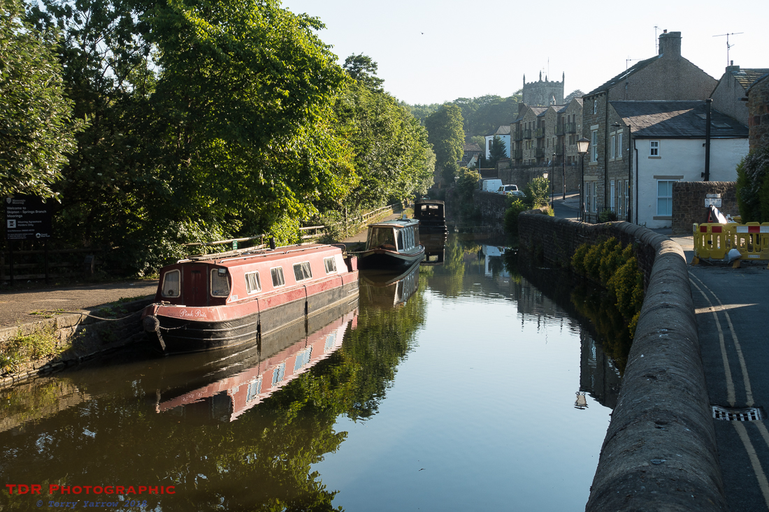
One of the joys of camping is waking up early on a stunning morning such as this! I breakfasted on serial bars and a lovely cuppa as the sun rose behind the tent sending beautiful shafts of sunlight through the steam coming from my stove. I didn’t hurry on this morning but I was still packed up and heading out of the camp by 7am. The early light and slight morning haze created a most atmospheric scene as I made my way back along the canal towards Skipton. There were curlew calling overhead and cocks crowing their wake up call as I walked – what a sublime morning!


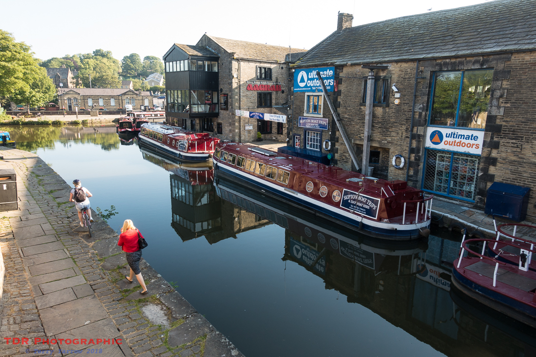
I reached the town with just a few people out and about starting their day. A large barge made its very slow and unhurried way down the canal – it seemed in total contrast to the people who were clearly hurrying to be somewhere. Sometimes I think we rush too much in life and that we should all learn to live ‘barge style lives’ – you just can’t hurry a barge! Is there really such a need to rush, rush, rush our way through our lives?
Leaving the town, I climbed up Park Hill and looked back across Skipton. Even this early in the climb, the views were great. The sheep unhurriedly breakfasted on grass.

I crossed the golf course and Tarn Moor with the haze of early morning still lingering. The day was already warm so I knew it wouldn’t be long before that burned off and the view cleared. My first objective, Sharp Haw, came into view.

This pointed hill is a mere 357 meters high but it stands proud from its surroundings so appears a lot higher. Ahead of me was another of those seemingly long drags upwards – I say ‘seemingly’ because it was probably in part due to the heavy backpack doing its best to pull me backwards 🙂 ! I met another fell runner out for his early morning training session and we fell into conversation briefly before he headed off up the hill. He would pass me again on the way down before I had even reached the top!

All the while whilst I was climbing, I could see the glint of metal near the summit and I assumed that someone had managed to drive a vehicle up there but when I reached the top, I discovered that it was in fact a rather grand stainless steel bench. This looked totally out of context to me and would have been much more at home in a local park! Beside it was a good example of up-cycling in the form of a ladder style created out of what looked like an iron bedstead. This took me back to my youth because as a child I slept on a bed just like this!

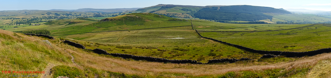
I climbed over the style and sat for a some time beside the trig point gazing at the awesome views from the top. It was a 360 degree panorama and photographs just do not do it justice – I took them anyway! I could have happily stayed there all day, it was such a beautiful place and I had it almost to myself apart from one other walker who passed me, calling out a hello on their way, as I sat drinking in the scene and drinking in some water too.
Ultimately I had to leave though and I dropped down off the top, passing yet more foxgloves on the way. At this point, my left knee started to complain so I donned my knee brace – whilst I don’t like wearing these, especially in hot weather, I knew that if I didn’t, it would jeopardise the remainder of the walk!

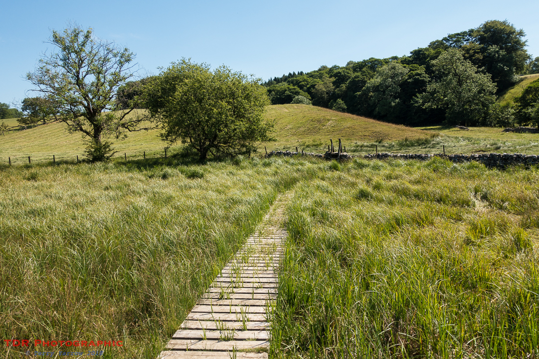
And I passed some interesting dry stone walls too, carpeted in lovely vegetation. It was clear that parts of this area were usually boggy, but not at this time. The mud had all dried up making walking easy and straightforward. Cattle and sheep leaned heavily into the walls, trying their best to find some little shade to cool themselves.

Passing through a farm, I reached Flasby, a tiny hamlet that comprised little more than the farm, an old manor house, and maybe a cottage or two. My route from here, followed Flasby Beck along a valley all the way to Hetton.
The walk was level and easy, and the beck was beautiful, especially when the dappled sunlight made its way through the trees. The gentle rippling sound of a stream is always a pleasant accompaniment to any walk.

I knew that on this day’s walk, there was only one place to stop for lunch and that was the pub in Hetton. Normally I carry lunch but on this day I decided to have a pub lunch which I enjoyed, sat out under the shade of an umbrella with views of the distant hills. I have to say though that this was no ‘ordinary’ walkers pub and the prices reflected that!

Feeling refreshed, I left the village and turned onto another of those old byways, Moor Lane. This long, dry stone wall lined lane takes a steadily uphill route all the way to the Winterburn Reservoir on Winterburn Moor. On a hot day such as this, it was another of those exposed parts with little shade to escape the heat of the sun.

The Winterburn Reservoir was constructed in the late 19th century, not to provide drinking water but to help maintain water levels in the Leeds and Liverpool Canal. It is fed by a number of becks and gills that flow off the moors. It is a very peaceful place with little sound apart from the birds and the bleating of the sheep.

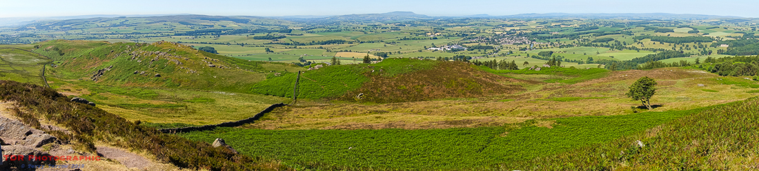
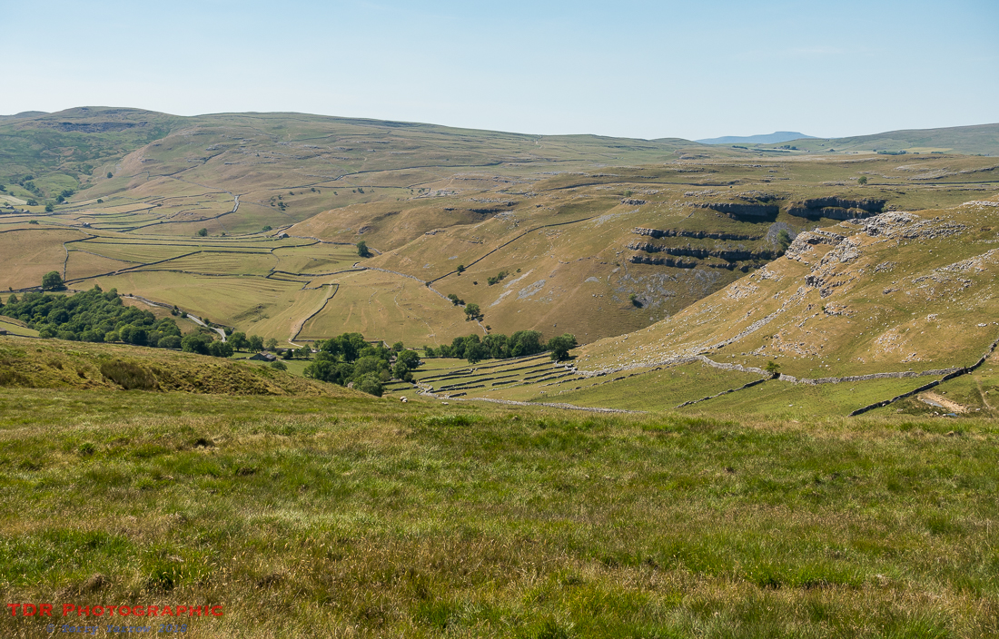
I crossed Hetton Common and continued to climb upwards, eventually reaching Hetton Common Head and then Weets Top. Although just 414 meters high, the latter has some great views back over the moors I had just crossed. The top also gave me the first view of my finishing point for the day.

Looking down across the valley in front of me, I could see Gordale Scar below, and in the far distance, Ingleborough poked its head above the surrounding hills. That would be a challenge for another day, and I already knew that with a still complaining left knee, that would be a challenge with a capital C. Before then though, I knew that I had other challenges that I wanted to beat!
Although it wasn’t yet evening, I had decided to make Gordale my stopping point for the night, but it wasn’t to be the end of my walking for the day!
I pitched my tent right in the mouth of Gordale Scar and then did what I often did, I had a quick shower and then set out walking again as I wanted to explore Malham village and Gordale Scar itself.
Malham has become a popular tourist destination thanks to the attractions that surround it. These include, Gordale Scar, Malham Cove, Malham Tarn, and Janet’s Foss, all of which I wanted to see. It is a lovely, if popular, village that sits at the top of the River Aire, with a couple of interesting bridges. I had intended to restock my food supplies but the single shop sold little in the way of food, and the cafe was closed. Instead, I made use of the pub and I sat in the shaded back garden to eat.


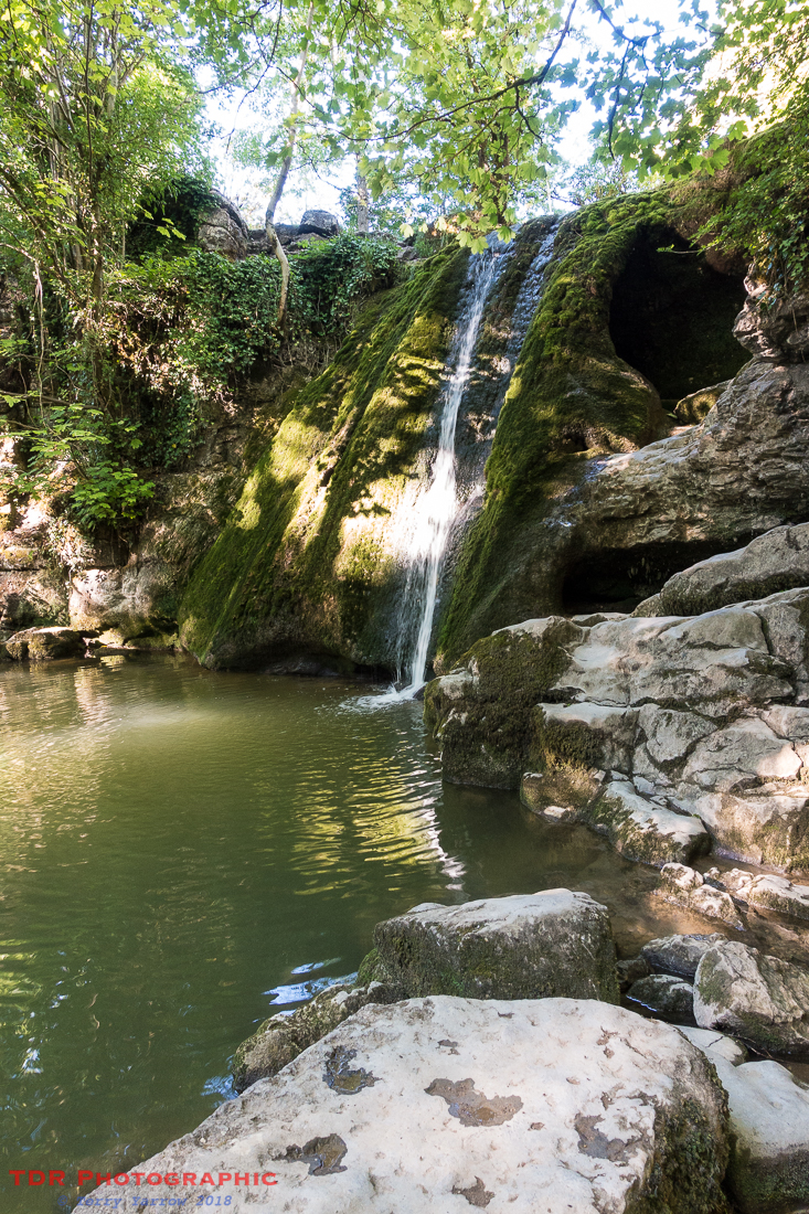
Making my way back along the river bank, I passed Janet’s Foss, a comparatively high water fall on the Gordale Beck, a tributary of the Aire, with a delightful pool below it. Normally there would be a substantial amount of water flowing over the limestone outcrop but in this dry spell, it was just a trickle. The falls are said to be named after Janet, a fairy queen, who it is claimed lived in a cave behind the falls. The pool below was once used for sheep dipping. It was a delightful place, especially with the dappled light, and I could see why this was such a popular place.
Leaving the water fall behind, I made my way back to my tent, but went straight past it and on up into the Gordale Scar itself. This is an amazing feature of the limestone Dales, with 100 meter high cliffs on each side. The gorge goes deep into the limestone plateau and it is normally in part occupied by Gordale Beck, but here, it was even more of a trickle. There were several groups of climbers in the upper reaches. It is not really known how the gorge was formed – it could have been caused by glacier melt water, or it could have been caused by a collapsed cavern. Either way, it was an awe inspiring place, and a great place to spend the night.


Late into the evening, I made my way back to my tent which was now in a somewhat shadier and busier camp site. This site is popular with Duke of Edinburgh Award students and there were at least two groups in on this night. Oh the intensity of the young conversations that drifted to my tent that night 🙂 ! But I was young once myself 🙂 ! In fact, despite my slight misgivings, they were generally fairly quiet, especially when they packed up and left for their next day’s walking at 4 am the next morning. And I thought I was an early riser 🙂 ! Actually, from a snippet of conversation that I overheard, I think they just wanted to get it finished 🙂 ! But kudos to them for making the effort and to those who set up this award scheme.
I laid in my tent thinking back over another awesome day in the Yorkshire Dales. Some 18.5 miles walked again in some pretty amazing scenery, and a spectacular place to sleep too, right in the mouth of one of the greatest physical features that you could wish to find! I knew that early the next day I would reach another awesome feature, Malham Cove, and I couldn’t wait.
Could it possibly get any better?!
If you missed Day 1 of this walk, there is a link here.
Thanks for stopping by.
Until next time,
Your friend
The Dorset Rambler
If you would like to contact me, my email address is terry.yarrow@gmail.com – comments and feedback are always welcomed.
All words and pictures in this blog are the copyright of The Dorset Rambler and may not be reproduced without permission.

Wow! What a fantastic walking holiday (and photos). Thanks for sharing. 🙂
Thanks so much Lynette 🙂