


It was a long day, a very long day! The reason being that we drove up to Pembrokeshire on the morning of first day of walking. We were up at 3.30am and arrived at Whitesands Bay, the start of our walk, at around 10.30am. This was the place we had finished our four days of walking in the autumn of 2017 and we were intending to walk the next section over the coming four days.
The beach was beautiful in the morning sun, the wide expanse of sand revealed by the receded tide virtually empty of people. Carn Llidi stood sentinel in the background like a knight surveying his land.

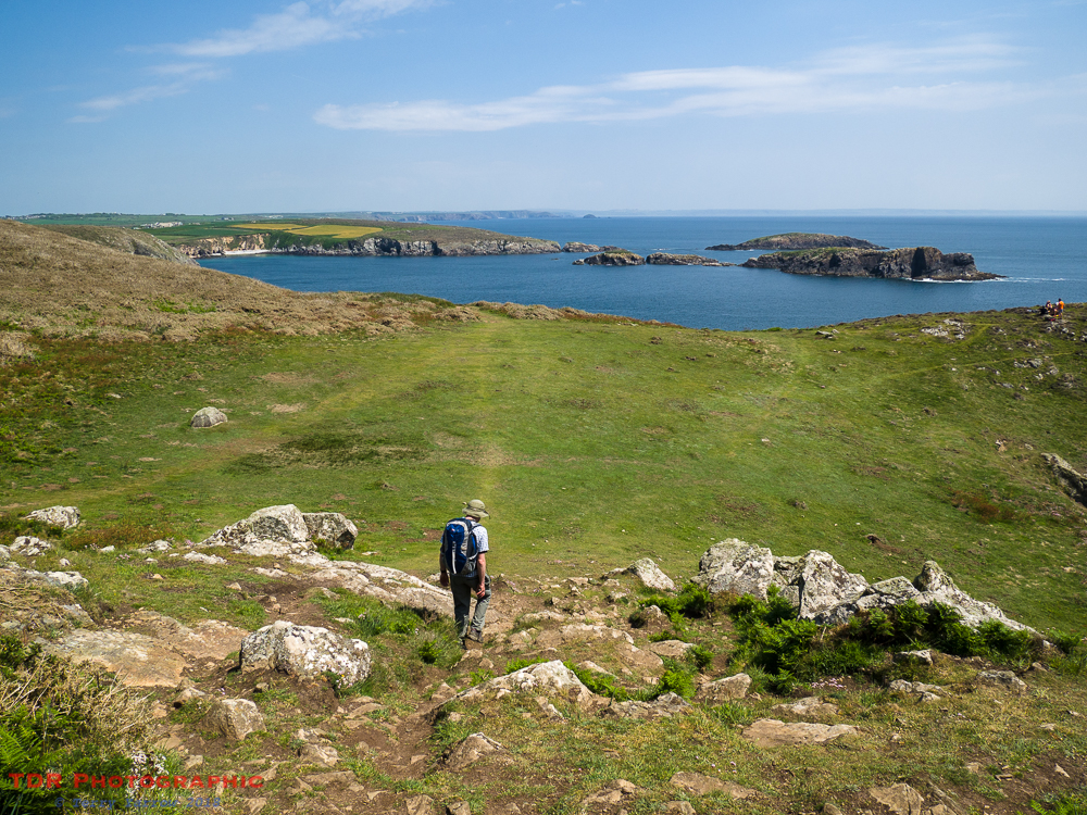
We made our way around the first part of the walk along a flat and flower strewn path to reach the lifeboat station at St Justinian. Four years ago when I backpacked this path over a two week period there had only been one lifeboat station, not including the tiny one to the left of the main station, but now a second had been added. The reason is that the previous station had become outdated as the lifeboat, which is in fact the St David’s Lifeboat, covers a substantial and rugged part of the Pembrokeshire coast, including the choppy Ramsey Sound.
St Justinian is named after a 6th century monk from Brittany who, somewhat disillusioned with life in the nearby St David’s Monastery, took himself off to the remote island of Ramsey to set up a more spiritual base. After his death, he was buried on the mainland nearby, in a small chapel that is now just a ruin, although subsequently, his remains were moved to St David’s Cathedral. St Justinian was a good friend of St David, Patron Saint of Wales, from whom the city took it’s name. The little harbour where the lifeboat stations stand is known as Porthstinian, derived from St Justinian’s Latin name of Stinan. As always, there are a number of legends surrounding the saint!
One such legend suggests that he was beheaded on Ramsey Island by his followers but that his body simply got up again, picked up its head and calmly walked across the sea to the mainland with it!
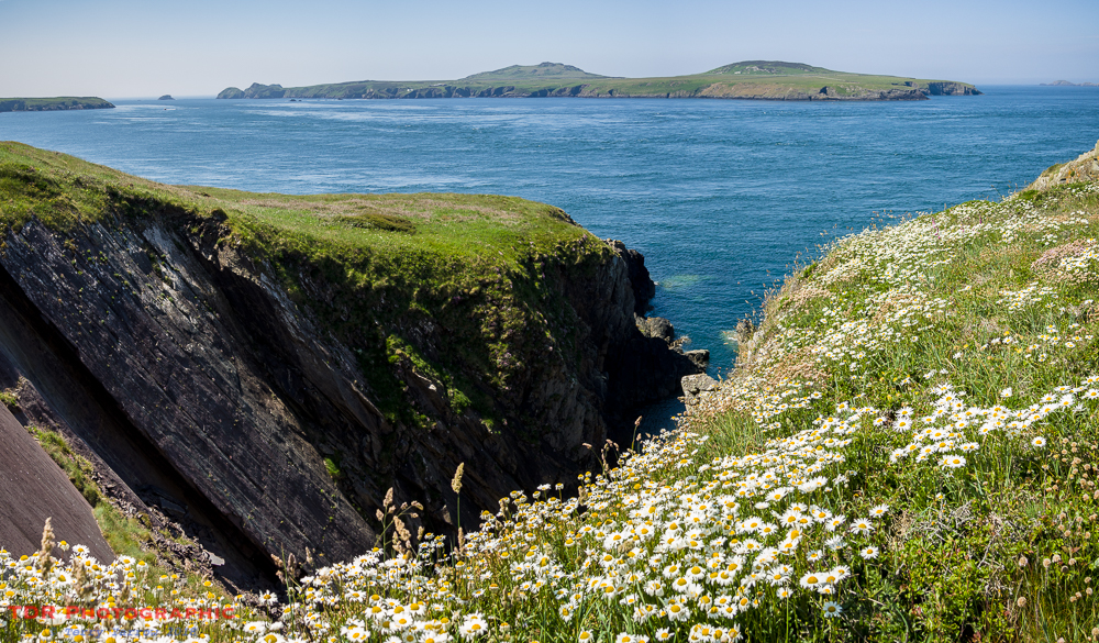
Interestingly, Ramsey Island itself is named after St David, being a derivative of his Welsh name. The island which was once an ecclesiastical centre with much farming and livestock is now in the hands of the RSPB with just the wardens in residence. Aside from some sheep, it is now the home of wildlife, notably a large grey seal colony, although in the summer months, conservation volunteers also descend.
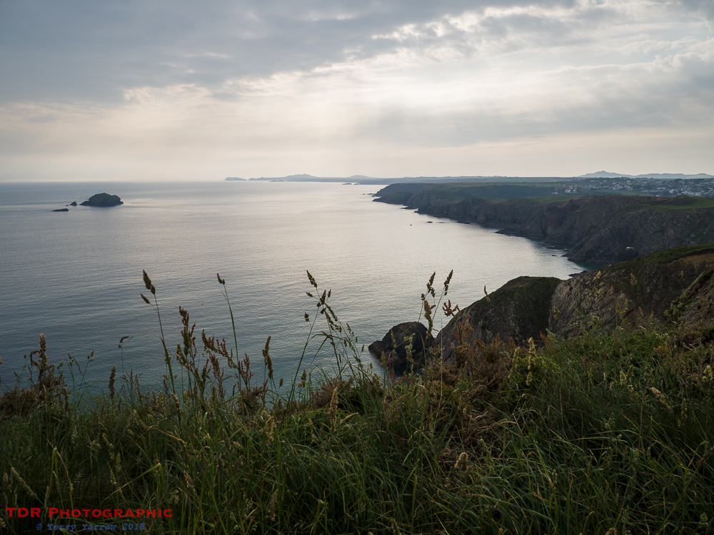
Despite its somewhat gruesome legends, this part of the Welsh coast is particularly beautiful with awesome views, lots of craggy rocks, and many islands of all shapes and sizes.
St David’s City is surrounded on three sides by sea so we were never far away from links with it. We soon passed Porth Clais, a one time busy port that served the city. Over centuries, many saints and pilgrims landed at this port en route to the monastery. It was subsequently used by many trading vessels, the breakwater being built to add protection in Norman times. This is a delightful place used mainly by pleasure craft now. And one of the benefits is that there is a kiosk selling teas and coffees – naturally, it would be rude not to 🙂 !

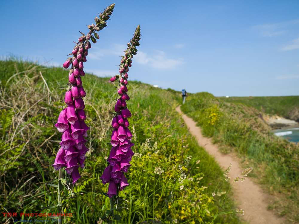
All along this coast were layers of wild flowers’ including foxgloves, buttercups, thrift or sea pinks, oxeye daisies, as well as beetles, butterflies, birds, and much more. There was always something of beauty and interest to admire.
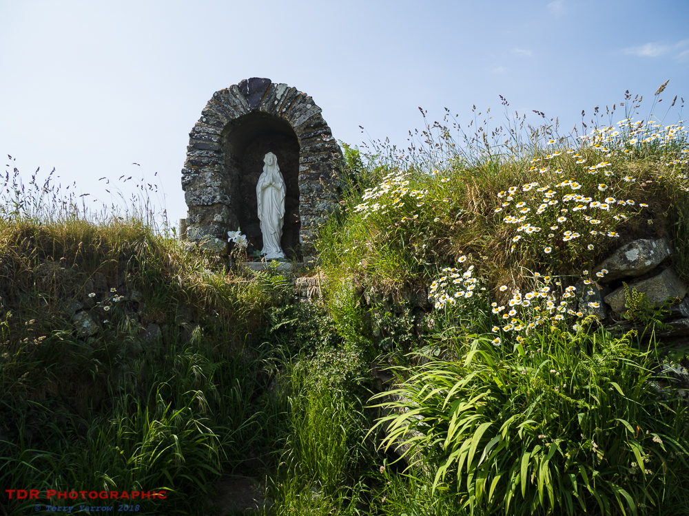
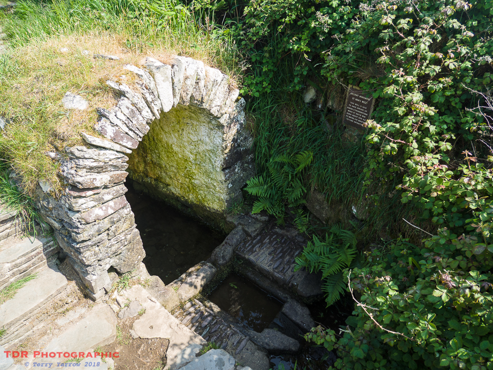
Connections with St David were everywhere. We passed St Non’s New Chapel beside the St Non Retreat Centre, the shrine to the Virgin Mary, St Non’s Old Chapel, and St Non’s Well. You may wonder what the connection is? Well, St Non was in fact St David’s mother, who gave birth to the patron saint here on a stormy day in AD462, the ruined chapel marking the spot. The holy well was famously a place of healing, renowned for curing eye diseases.


A little further on, we came across Porth Y Rhaw, another meltwater channel. A lovely craggy inlet, and just up the valley, no fewer than nine more wells that were also said to have healing properties. The area is actually known as Nine Wells.


The day up to this point had been beautiful, with bright and warm sunshine bringing out the awesome colours. As the day wore on though, cloud started to appear at times, the light taking on a more moody glow. This was to have consequences later but for now, it just added a lovely atmosphere to an already beautiful scene!

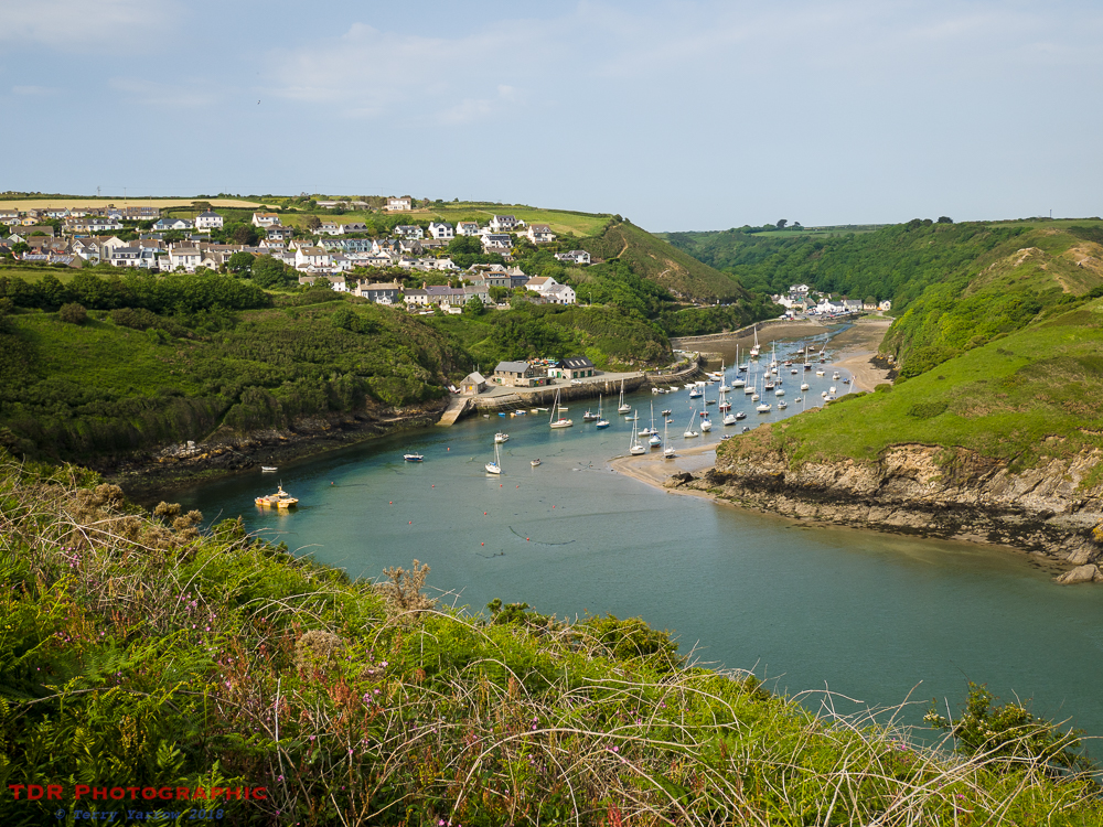
After around 13 miles of walking, Solva came into view as we rounded another headland. This is a ria, a drowned meltwater channel that extends right into the heart of the St David’s peninsula. In the 1300’s, this was just a small port but it increased in size to become one of the main trading centres for this part of the coast. It was also the main lime burning centre for the peninsula with as many as 10 kilns in operation at one time. Once again, this has now become a centre for pleasure craft.
With another 5 miles to walk, we moved swiftly on towards our stopping point at Newgale. Leaving Solva behind, we soon lost the sun again as cloud built up.
Approaching our 18th mile of the day, the rain began to fall! But this only added to what was to become a great end to the day. It had been hot and our feet were now feeling sweaty. The water looked inviting even in the rain! So we dropped down to the beach to walk the last mile along the sand, kicking off our shoes and socks because there was a headland to get round and the only way was to paddle.

With an eerie coloured sky and the wet sand reflection the moody light, this was an exceptional end to what had been a great day’s walking. We lingered a long time on the beach, watching the sun go down and cooling our feet in the chill water with just the odd fisherman for company.

If you would like to read the first section of the walk which we completed in 2017, the links are below:
Day 1 – St Dogmael’s to Newport
Day 2 – Newport to Llanwnda
Day 3 – Llanwnda to Trefin
Day 4 – Trefin to Whitesands Bay/St David’s
Thanks for stopping by.
Until next time,
Your friend
The Dorset Rambler
If you would like to contact me, my email address is terry.yarrow@gmail.com – comments and feedback are always welcomed.
All words and pictures in this blog are the copyright of The Dorset Rambler and may not be reproduced without permission.

great section of walk.
It was Simon, we really enjoyed it as there is so much of interest there.
are you still over there on your walk?
No, back home now and planning my next trip away 🙂
I have done my knee in unfortunately! You know that old joke ‘a man walks into a bar…’ – i didn’t laugh!
Ah, no, sorry to hear that. I have trouble with my knees but it’s down to age!
Beautiful landscape and photos. An interesting post. 🙂
Thanks so much Lynette 🙂
Reblogged this on World4Justice : NOW! Lobby Forum..
Makes me want to get on a plane and come over and see that beautiful part of the world that you like to stroll through. Have a great day!
Thanks 🙂 You should so do that 🙂
With my handicap, I’ll just enjoy the beautiful photos that you share.
Ah, thanks Lee, you are very kind