

Day 4 – Grasmere to Patterdale – 8.5 miles
I woke as expected to rain! Pouring rain! But the forecast suggested that it would improve later in the day so I took my time packing up in the hopes that conditions might improve earlier than anticipated – it was a forlorn hope! I had been intending to walk beyond Patterdale to wild camp beside Angle Tarn but once again, the conditions were far from ideal so I settled on a slightly shorter day by overnighting in the Patterdale valley.
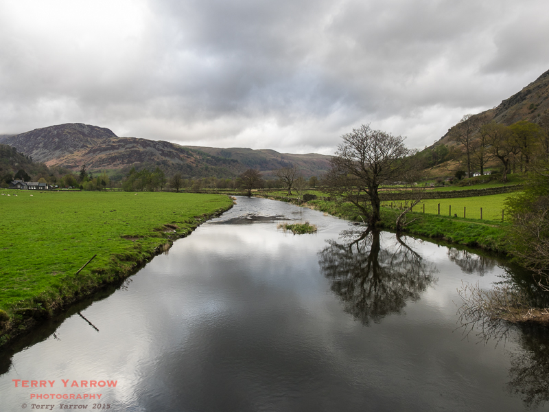
Leaving Grasmere, I could immediately see how low the cloud was – there would be no great views today!
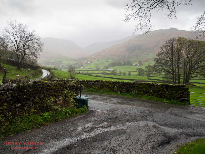
The route briefly follows the country lane before crossing the A road to join the track that climbs steadily up to Grisedale Tarn. Initially the wind was on my back but this changed as I climbed out of the valley towards Great Tongue, the tongue shaped hill in the centre of the picture below.
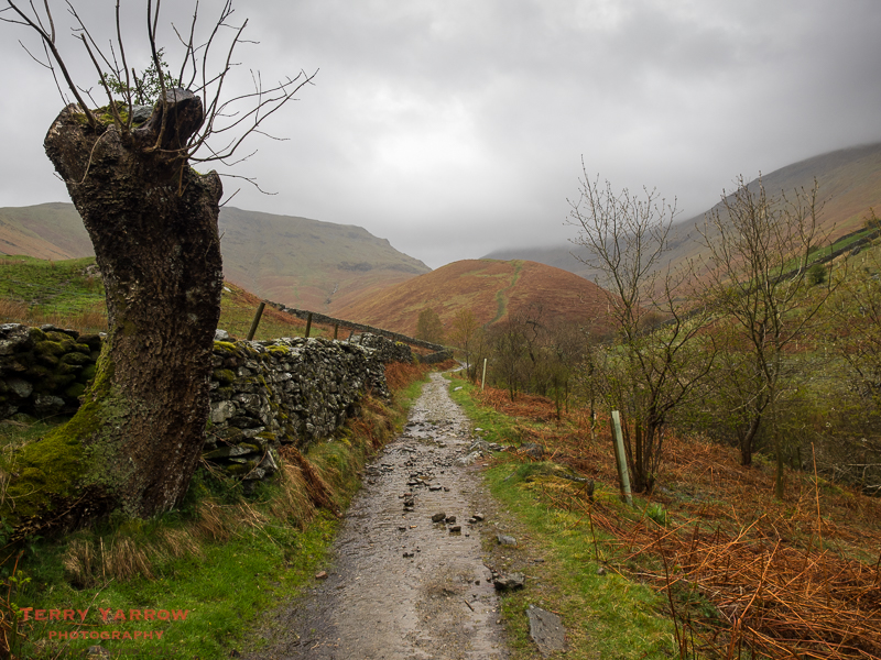
At the foot of Great Tongue, the track divides and you can choose to go East or West of the Tongue. With the very windy and wet conditions, I chose the path that runs to the East of the hill because I thought it might be more sheltered, and I climbed upwards beside Tongue Gill.

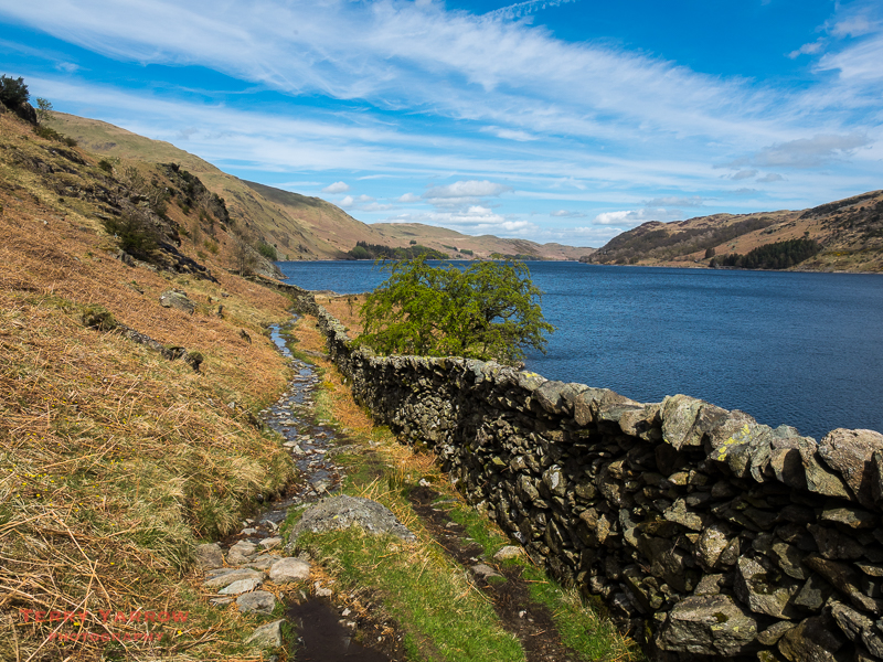
Even sandwiched between hills there was little relief from the driving rain and wind. As in previous days, the path climbed gently at first but became ever steeper as I climbed higher. After nearly 24 hours of rain, the rivers were full and even the path itself had become a stream so that I was walking in streams of water for most of the day. I stopped to look back down Tongue Gill trying as best I could to keep the rain off the lens.

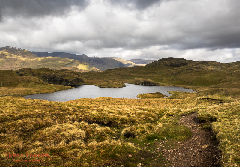
With the unrelenting conditions, it seemed to take an age to reach the top of the climb where I expected to find Grisedale Tarn. In fact as often happens, it was a blind summit and there was more climbing to do in oder to reach the tarn.
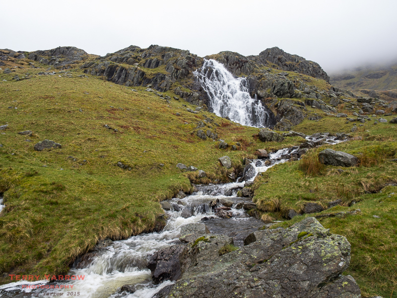
Apart from pausing to take the odd picture, I had not stopped all the way up the 600 meter climb, so it was a relief to finally crest the real top and to look down on Grisedale Tarn. It was interesting to think that I had intended to wild camp here last night. With the gale force wind whipping across the pass driving the stinging rain into my face, I knew that it had been the right decision to overnight in the valley instead! How I wish that a photograph could fully convey the conditions I was experiencing as I stood at the top of that pass!
At the end of the tarn, the route divides into three suggested alternatives. The main route drops straight down beside Grisedale Beck into Patterdale making the tarn the highest point of the day. However, there are two suggested higher level alternatives – one takes the zig zagging path up to the left in the picture below to reach Helvellyn via Dollywagon Pike, and the other takes the path to the right and climbs up over St Sunday Crag. My intention all along had been to take the high level route climbing over the Helvellyn summit before dropping down across the wonderful Striding Edge. What should I do?

Looking up, I could not even see either of the high level alternatives and in fact, looking back across the tarn, the cloud base was barely clear of the tarn itself. I debated which route to take as I really wanted to go higher even though it would mean another 1,000 feet of steep and tough climbing – Helvellyn is spectacular and Striding Edge is one of the best knife edged ridges around.

Ultimately common sense prevailed and with a somewhat heavy heart I headed across the top and took the path that dropped down beside Grisedale Beck. Aside from any risk involved in climbing up into dense cloud, there seemed little point if the amazing views were not visible!

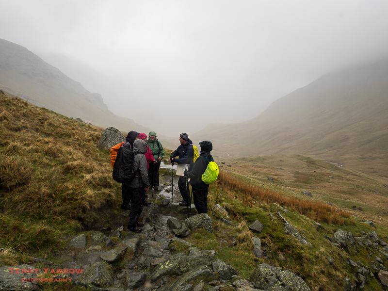
As I started downwards, walking often in ankle deep water that was running down the path, I noticed two groups of walkers below me comparing notes – some of them, three in fact, looked familiar. It was Chris, Chris and Steve, the charity walkers from yesterday. We spent the rest of the day walking together.

Gradually as I dropped down the valley, visibility improved and as we reached the lower part of the valley, the sun even made an appearance. The forecast had been right……but why couldn’t it have cleared earlier 🙂 ! It was at this point that I took a tumble! Everything was so wet and slippery and I just lost my footing on the rain sodden grass. Fortunately all that was damaged was my pride 🙂 !

I arrived at the end of the walk in bright sunshine although the tops were still very much in the clouds. It was a relief to find a walker friendly pub in Patterdale and to be able to remove my wet rucksack, waterproofs and boots and to sit in the bar and dry off 🙂 …….with a pint of Wainwright Ale of course 🙂 !! It was interesting chatting to the landlord whose whole family are involved with the C2C. He told me that his 9 year old daughter and his 78 year old grandmother had both completed the walk three times. What a great achievement for both of them – and at each end of the age spectrum!
Later in the evening I returned to the same pub and had a meal with my three charity walking friends. It was a great evening……and I even managed to save some of my pizza for lunch tomorrow 🙂 !

It had been an awful day in terms of weather and it had been a real challenge to keep everything, especially the camera, as dry as possible. Yet, somehow, it had been a fantastic day too despite the disappointment of not being able to climb Helvellyn.
Day 5 – Patterdale to Shap – 16.2 miles
I was up early and out on the trail by 8am on a cloudy but DRY day 🙂 ! I made my way down the road and crossed Goldrill Beck, the river that feeds Ullswater, to pick up the C2C path again. The camera, now dry, immediately came out again 🙂 !
At this point, I noticed a strange sight – lambs wearing polythene coats. They reminded me of the Pac A Mac’s that used to be popular many years ago. I guess it is a reflection on how bad the weather has been this year.

The climb out of Patterdale started almost immediately and was a steady uphill grind but with ever broadening views and ever brightening weather it was a lovely walk, especially after yesterday 🙂 ! As I climbed higher, the wind became keener and it felt strange to have the path to myself as there was no sign of any other walkers.

I stopped for a while and looked down on Brothers Water, one of the smaller lakes and a local lady out walking her dogs caught up with me. She was a budding photographer and naturalist and, with common interests, we chatted as we walked together. Although she lived in the Lake District, she felt it had been tamed, describing it as a ‘huge adventure playground with well manicured paths that had become too busy’. She much preferred what she described as ‘the true wilderness of Scotland’! I could see what she meant as it has certainly become a lot more popular thanks to Alfred Wainwright, but I didn’t necessarily agree.

She wanted to take photographs on the shore of Angle Tarn so I bade farewell and continued on my way, looking back at the beautiful tarn below. It brought back memories of a day, much warmer than this, when I had swum in the tarn just to cool off after a sweaty climb many years ago.
It seemed strange that apart from the dog walker I had passed no other walkers, and neither could I see any in the distance. I almost wondered if I had taken the wrong route 🙂 ! Actually I did take a detour but it was a deliberate detour to take some photographs. Often I add miles to my walks because I wander off the trail to find different views 🙂 !

The light was fantastic with dark clouds scudding across the sky throwing huge shadows over the landscape. It was a dream day for a photographer! With skylarks singing over head, it was a multi-sensory experience. In particular, the view down Bannerdale, one of the two valleys that make up Martindale, was quite spectacular.

In terms of severity, this was down in the guide book as the toughest day of the whole walk as its highest point was Kidsty Pike at a fraction short of 800 meters, and total climbing of some 4,400 feet on the day. However, perhaps because of the conditions over the previous couple of days, it seemed somehow less severe.

I reached High Street for just a short time before turning sharply to continue to climb over the top of Kidsty Pike with the now really strong wind doing its very best to knock me off my feet. It was cold and blustery but was an exhilarating walk. I stopped often just to soak up the views and of course to take more pictures.
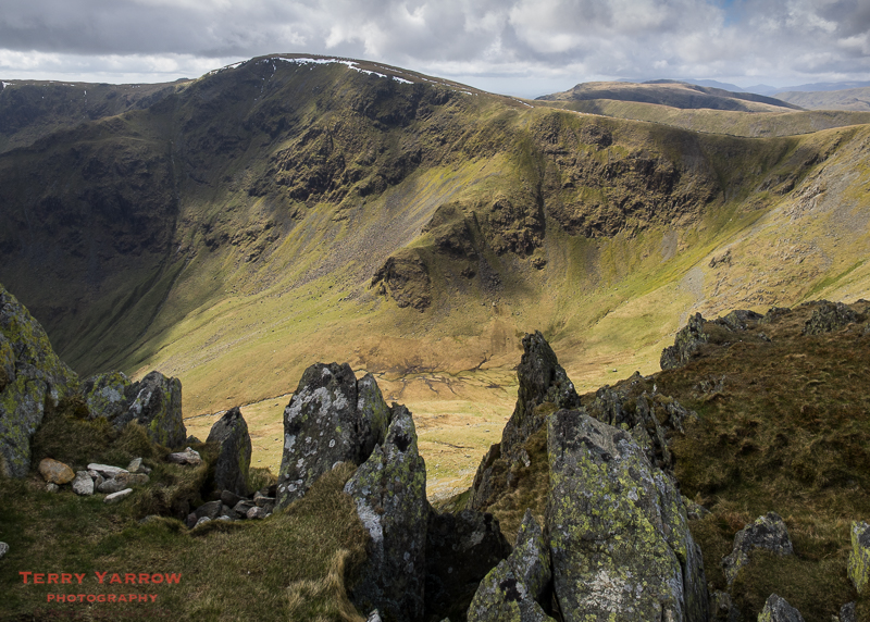
With quite a few miles still to walk, I pressed on over the top and followed the path that drops steeply down towards Haweswater far below. The climb down is knee wrenching but with amazing views across the lake, it was a delight. As I reached the lower parts, the wind dropped, and the day, and I, warmed up!
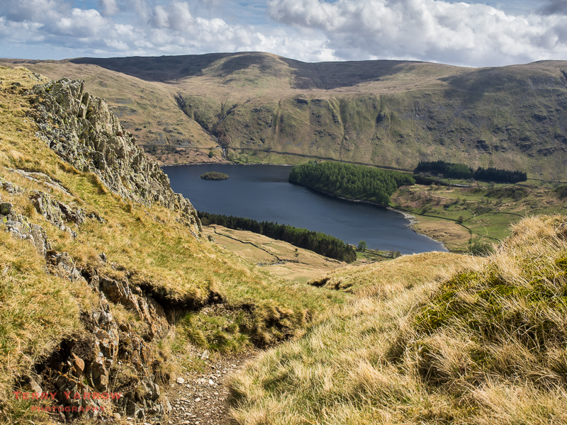
Haweswater is a surprisingly long lake, some 4 miles from end to end. In fact, more correctly it is a reservoir as a dam was erected in 1935 that raised the level of the existing, much smaller, lake by nearly 100 feet, flooding the villages of Measand and Mardale Green in the process. Not only were people evacuated but their homes were all demolished as was the pub and church – the stone was used in the building of the dam. Eerily, like something out of a movie, all bodies were also exhumed from the graveyard and reburied at Shap. This, plus the fact that the valley was seen as one of the most picturesque, caused a public outcry. The water from the reservoir serves the people of Manchester. Alfred Wainwright described it this way, ‘Man works with such clumsy hands! Gone for ever are the quiet wooded bays and shingly shores that nature had fashioned so sweetly in the Haweswater of old; how aggressively ugly is the tidemark of the new Haweswater!’ He did though describe it correctly as a ‘still noble valley’!
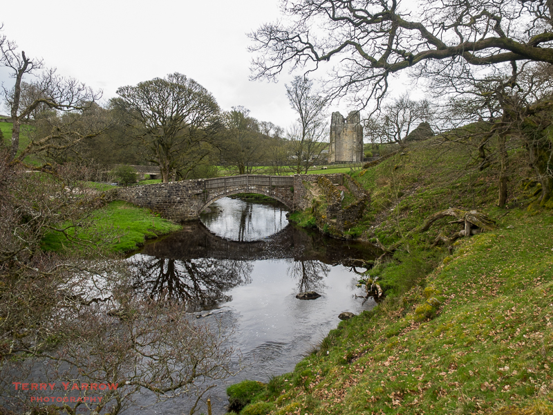
The path that runs along the shoreline undulates and has fine views across the lake. It was a pleasure to walk although it seemed to take a long time to walk the whole length and pass the dam at the lower end. Eventually however, I left Haweswater behind and I headed out into the countryside at the lower end of the valley, following the route of Haweswater Beck and the River Lowther to reach Shap Abbey, a 12 century Premonstratensian community. Although the abbey escaped the Dissolution of the Monasteries, the building was closed in 1540 and most of it, with the exception of the tower, was demolished.
Along the last few miles I passed two honesty boxes. These are a feature of parts of the walk and are very welcome when supplies are running low. I made use of the one below, provided courtesy of a local walker-friendly farmer near the abbey. This last part of the route had been quite boggy and hard going……but it was nothing compared to what was to come!

I finally arrived at Shap, my stopping point for the night, at 7pm and having showered I spent an hour or so exploring the village. I had loosely arranged to meet up with Matt and Ben again as they were finishing their long weekend here but sadly I missed them.
What a fantastic day this has been – the toughest so far maybe, but also the best so far, with amazing weather, awesome views and fabulous scenery. I was tired and very satisfied as I settled down for the night.
Thanks for stopping by.
Until next time,
Your friend The Dorset Rambler.
Comments and feedback on this blog are welcome. If you would like to contact me, my details are on my website which is http://www.yarrowphotography.com.
If you would like to join me on my walks, my Twitter feed is http://twitter.com/adorsetrambler.
All photographs, poems and words in this blog are the copyright of The Dorset Rambler and must not be reproduced without permission.

You were very wise to avoid Striding Edge in such poor weather. High winds and slippy ground is not a good mix up there. The mountains don’t go anywhere and will be there another day as they say. Have to say I think you are right about the High Street leg, the Far Easterns are a stunning part of the Lakes, made all the better by the feeling of being more away from it and slightly isolated than you get in the Central fells.
Thanks for your comment. I’ve done Striding Edge a number of times in the past but had really hoped to do it again. It was just bad timing that bad weather blew down from the north.
A shame that you had to abandon Striding Edge this time. I had the same experience two weeks ago, when we’d intended to take that route but the winds were far too strong to go up there safely. I really enjoyed reading this post, and loved seeing how many of your photos feature the classic dry stone walls – they are so strongly characteristic of the Lake District!
Thank you. Glad you enjoyed reading it. I certainly intend doing the walk again and hope to do the high level routes next time…….weather permitting 🙂
Still enjoying your C2C. I was interested in the lower route that you took instead of Striding Edge, as that is what we would do, (because of me! )! The only thing is that I was looking forward to seeing exactly what Striding Edge was like once you are up there and walking it!
I’ll have to find some pictures.
Loved reading about your day again.
John & Liz
Clun
😊
Thanks John and Liz. I have quite a lot of pics of Striding Edge from previous visits but unfortunately none on digital. There are plenty on the web though 🙂