

Some years ago, I backpacked the Cotswold Way which is a National Trail running 102 miles from Chipping Cambden southwards to the city of Bath, but I never quite managed to finish it because of foot problems. Years later, just over a week ago in fact, I finally walked the last few miles to complete the trail.
I’ve just looked back at my journal and it was in fact June 2008 when I walked the Way and I wrote at the end of the first day, ‘Here we are again, the first day of my Cotswold Way walk, just over 100 miles in 5 days, but I doubt if I will make it all the way’! I got just 5 miles into the walk when my Achilles tendon started to hurt. By the end of that day, carrying a heavy rucksack, it was agony! I should have stopped, that would have been the sensible thing to do because to continue could do some long term damage, but I didn’t! I lived on painkillers, used my walking pole as a ‘crutch’, and only half laced my shoe to take the pressure off…..and I hobbled on for 5 days.
After those 5 days, with detours for overnight stops, I had already walked 105 miles – on that last day I had already walked 20 miles – so when I reached the Grenville Monument, just north of Bath, I finally decided that the last 8 miles were just a step too far and I decided I could stagger no more! I stopped at that point, not only on the Cotswold Way but on walking itself because it took months for my Achilles tendon to heal.
In terms of the Cotswold Way, that ‘pause’ lasted 14 years because only a week or so ago did I finally get round to completing the trail. To be honest, I had thought in any event that those last few miles would be a bit of an anti-climax, being through the urban hinterland sprawl of the city, but how wrong I was!
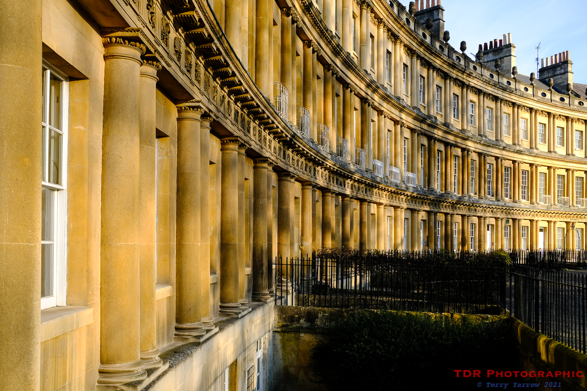

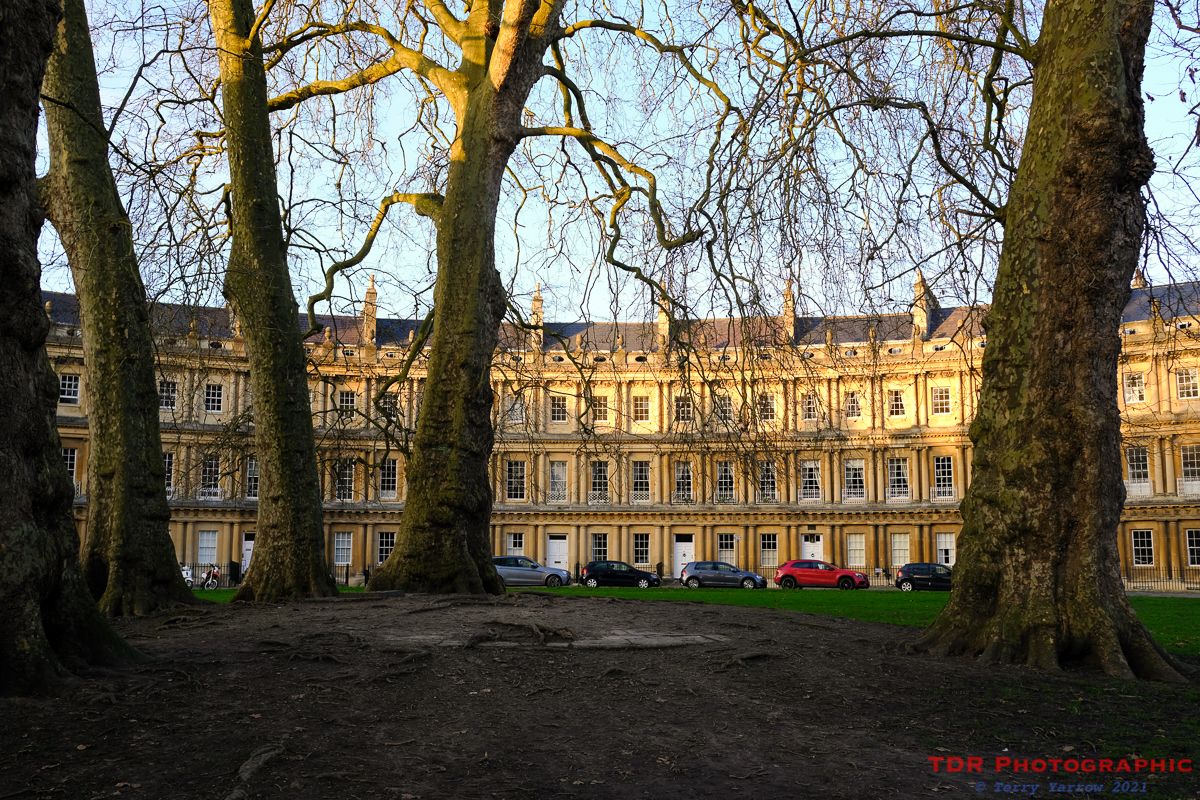
The Cotswold Way starts or finishes at Bath Abbey so that is where I started my walk, and in fact I walked it in both directions, choosing to go out and back by the same route. It was a lovely morning and the winter sun really brought out the beautiful colour of the Bath Stone that was used in building the city. The first part of the walk was a cityscape but what a cityscape it was, such amazing Georgian architecture. The route passed the Circus, a 360 degree circle of Bath townhouses, broken only at the four 90 degree segments to allow access roads, and then shortly afterwards, the Royal Crescent, a semi-circle of similar houses. Known simply as the Crescent originally, the additional title of ‘Royal’ was added later when Prince Frederick, Duke of York and Albany, had stayed there. Interestingly, it is only the great facade that is symmetrical and uniform, as that was built as a whole. Each purchaser then employed their own architect to build a house to their own design behind the section of facade they had bought.
It wasn’t long before I left the city behind, climbing first through parkland and then common to reach the start of the ridge that leads up to and then around Kelston Round Hill. Despite the closeness of the city, I could already feel that I was out in wild countryside. Turning to look back, I could see the city spreading across the valley below.

The paths were a delight to walk, with amazing views all around, and mainly solid ground under foot. The climbing was steady rather than steep but nevertheless, reached around 240 meters before plateauing at the racecourse. The last couple of miles skirts around the racecourse and then a golf course but still it follows the edge of the hill so the views continue. By the time I reached this point, the cloud had gathered overhead and the temperature had dropped significantly so I was glad I had windproof clothes on.

Eventually I reached Hanging Hill and the ridge where the Battle of Lansdowne took place in July 1643. I can only assume that Hanging Hill took its name from the activities that took place there as I have not been able to find anything definite on its name. The battle was part of the English Civil War with the Royalists attacking from the west and north whilst the Parliamentarians controlled the hill. Despite having to attack up the steep scarp slopes, it was the Royalists who gained the upper hand, the Parliamentarians retreating to Bath under cover of darkness. Despite their seeming success though, they were unable to capitalise as they had lost so many men that they also were forced to retreat. The Grenville Monument was erected on the hill to commemorate the heroism of Sir Bevil Grenville, a Royalist commander, who died during the battle.

The site of the battle was also the site where I lost the battle with my Achilles tendon 14 years previously, and it was the end point of my walk, so I turned around and headed back the way I had come. On the way down, I met a lovely couple who were in the early stages of exploring the Cotswold Way and we fell into conversation. I think for me, that this is one of the best things about walking, meeting and chatting to like minded people who are part of the walking or cycling community. As I look back over my many years of walking, I have many great memories of people I have met along the pathways. Some, I am still in contact with after many many years, partly through my blog, others, because we didn’t exchange contact details, I have not heard from again but I often wonder where they are now and whether they ever finished the trail they were walking when I met them. I often wish I had exchanged contact details with more fellow walkers as I have fond memories.

My walk ended where it began, at Bath Abbey, once more bathed in sunlight as that yellow ball sank to the horizon. My walk had been so much more enjoyable than I had expected, and I was pleased that I had finally completed the Cotswold Way. One of my plans is to backpack the whole trail again because naturally, walking with constant pain did take the edge off what was an excellent route. But that is for the future. For now, I’m just enjoying my memories of walking those last miles. By the time I got back to the car I had walked 18 awesome and interesting miles – it may not be Dorset but it was great walking 🙂 !
Oh, and if you are reading this and we have met on the path somewhere, do get in touch, I’d love to know how you are doing 🙂 !
Stay safe, stay active, and thanks for stopping by.
Until next time,
Your friend
The Dorset Rambler
If you would like to contact me, my email address is terry.yarrow@gmail.com – comments and feedback are always welcomed.
All words and pictures in this blog are the copyright of The Dorset Rambler and may not be reproduced without permission.

I am glad you finished the walk and wrote about it. It gives me the idea of taking at least some of that same walk if I’m able to get to Bath this year or next. Really enjoy your blog and great photographs! —Paul Kreider, Seattle, WA
Ah, thanks Paul for your kind and encouraging comment. I really hope you get to do some of the walk as there are some beautiful places along it.
I seem to remember Lansdowne features in Quiller-Couch’s novel The Splendid Spur, in honour of his fellow Cornishman Sir Bevil.
Thankyou for sharing your valuable thoughts Terry! Lovely photos too. It is encouraging to read your words and relive that part of the walk. It is more beautiful than we thought it would be and like you we were also pleasantly surprised with how enjoyable the Bath architecture is and we live close to Bath! It was a completely different feeling that a usual visit to Bath!