

It was one of those wonderful winter days – you know, the ones we don’t get often! After all the wet, grey days, this one dawned to bright sunshine and a hard frost – I even had to scrape the ice off the windscreen. Perfect for a walk along the Dorset coast!
I set off from the small but popular village of Lulworth and headed up the road for a time before turning off onto what I call the inland coast path. This path runs along the ridge of hills parallel to the coast path proper. That will be our way back later. When I reach the farm gate at the top of the rise, I cannot help but lean awhile and look back the way I had just come to the sound of far away dull thuds from the MOD firing range in the distance.

Much as I like to just drink in this view, there is a chill breeze and I need to move on so I reluctantly turn to continue along the ridge. Not that I need to be reluctant as there are views aplenty all along this ridge.
I pass the first almost immediately, the wonderful valley that goes by the dubious name of Scratchy Bottom! I love this valley with its curving sides layered with lines of thick grass. It is like a boomerang that leads out to the sea.
Its name actually has nothing to do with our proverbial posteriors, or anyone or anything else’s for that matter (it is usually inhabited by sheep or cows) – it just comes from the fact that the valley bottom was once covered in scrub. Its main claim to fame is that in 2012, it came second in a poll of Britain’s worst place names. Wouldn’t you believe it, the place that came first, Shitterton, is also in Dorset! Oh, and the valley is also ‘famous’ for having been used as a film location!

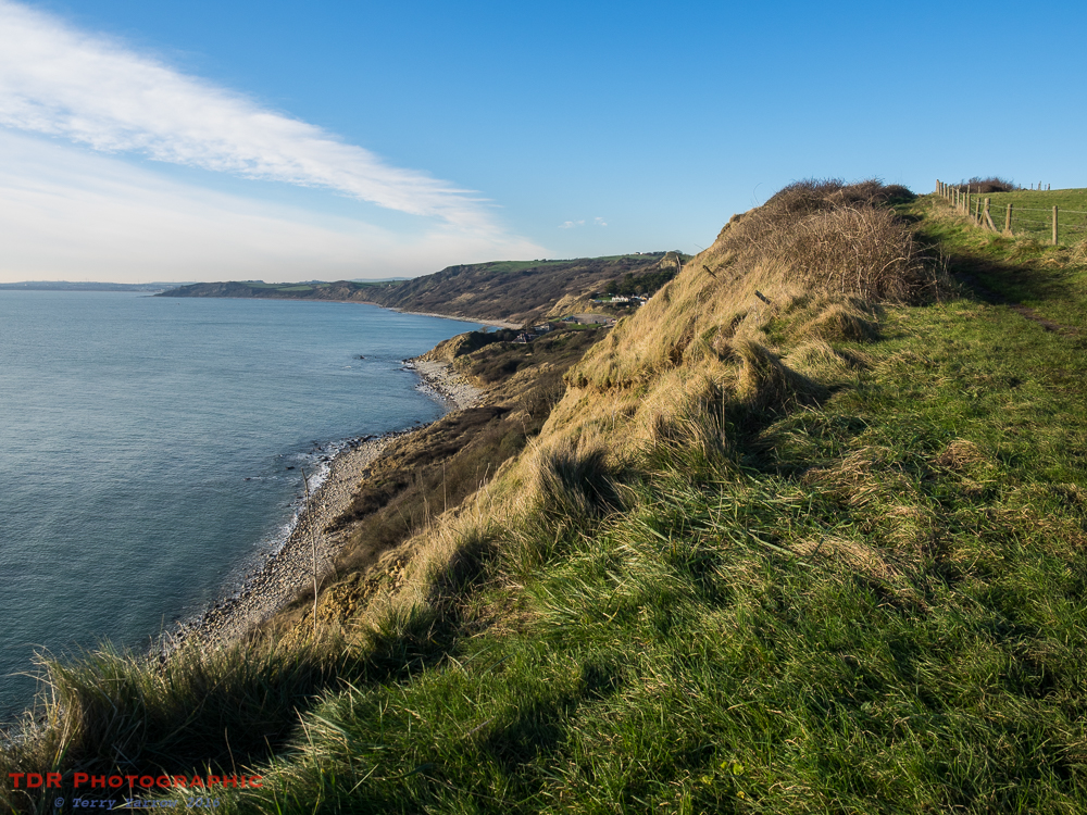
Aside from the fact that a walk along this ridge is ‘bracing’, it is also fantastically exposed, open and spacious with a carpet of lush and well drained grass under foot. These are chalk hills. In summer, this is one of my bare foot walks………but not today! Today, my feet will stay tucked up warmly inside sock and boot! I walk with a great sense of freedom, looking across to the distant Isle of Portland.

One of the interesting and unexpected features of this remote place is a series of three shell sculptures, each sheltering in its own stone cupboard. I say three because that’s how they started, but in fact one is now conspicuous by its absence. These were carved by Peter Randall in 1985 at the request of the Weld Estates as part of Common Ground’s New Milestones project. The intention was to encourage small scale art works that would celebrate history and the natural world.
But these are not the only unexpected things on this walk.

Just a short distance further along and a few hundred yards inland stands an obelisk. Below me on the cliff top stands an identical obelisk. They are functional rather than decorative and for years these puzzled me every time I passed them – why were they there and what was their purpose? I could find nothing in books or on-line. One day, I was determined to find some answers so I sat with phone in hand and made some calls…..which gave me the answer I was searching for.
The answer, or at least part of it, was found in a rather tasty tome entitled ‘The Channel Pilot Part 1’ dating from 1908 which referred to ‘Two white beacons, 24 feet high for the use of His Majesty’s ships when prize firing, have been erected on high land east of White Nose (now known as White Nothe)’. Prize Firing was an annual competition to test the skills of the various ships to see if they were ready to go to war so these two obelisks aided that competition.
Across Weymouth Bay in the picture below, you will see the Isle of Portland and just to the right of that stands Portland Harbour, said to be the second largest man made harbour in the world. This was a busy Royal Naval base until 1995 so in the early 1900’s battle ships would leave the harbour and steam up and down in a straight line whilst firing at targets moored out to sea. Clearly these two obelisks were used to enable the captain to steer his ship in a straight line across the water. Oh, and as you can see, the obelisks have long since lost their white coating.

Moving on, I continued to follow the inland path, deeply rutted from farm machinery but still with some great distant views. After several more miles, my route took me along a track which curved round the head of the ridge, dropping down towards the coast path proper.

I passed through an unusual landscape, various hillside terraces, some old wooden shacks left to rot, and what appeared to be a derelict toilet block. Clearly, this was once a holiday park. It amazed me how nature so quickly reclaims its own!
Eventually I reached the coast and turned east to head back towards my starting point and after a short time, I stopped to look back towards Osmington Mills, a tiny coastal hamlet which once had a fishermen’s slipway until coastal erosion destroyed it. In 1927, the Minx, a coal barge, broke her moorings and was wrecked on Frenchman’s Ledge below. Parts are still visible today.
The Minx is not the only wreck here as along this part of the coast, there are many wartime relics. There is evidence of lookout posts, pillboxes, several bunkers, a communications centre and even the remains of wartime gun placements. At one time there was a massive radar station on the clifftop too. There is also a great deal of mud!
I stopped to chat to a retired man who was taking a short holiday at Weymouth and who had come out to explore the coast path. He was walking in the opposite direction to me so had already walked the most severely steep parts – I still had those to come…….but he still had several miles of mud to walk through. We compared notes 🙂 !

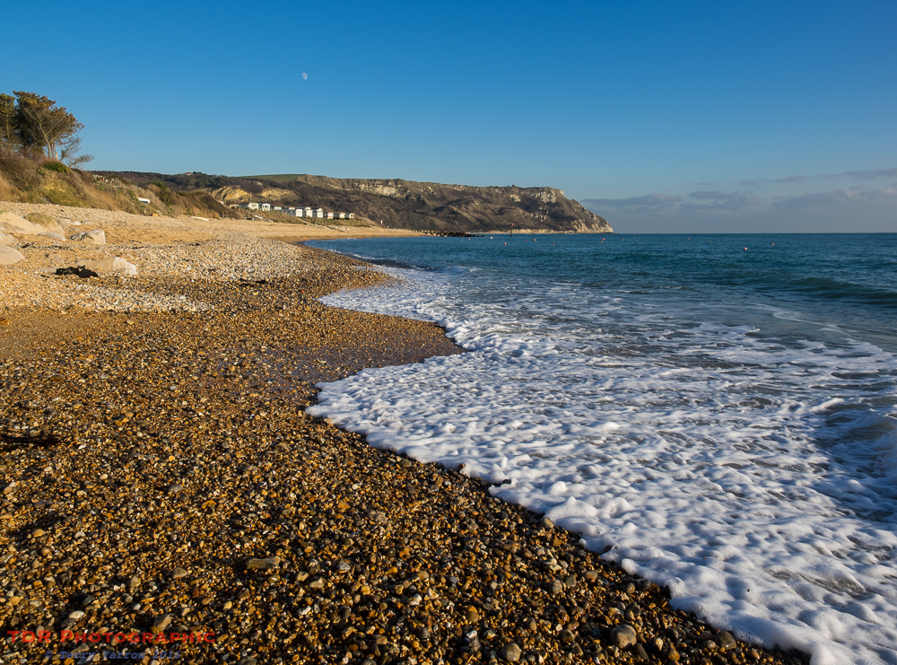
Having slipped and slid for several miles – I was thankful for my walking pole! – I finally reached the beach at Ringstead Bay and stopped for a late lunch. This one time fishing village is a beautiful place to spend some time, especially on a gorgeously sunny day such as this and I sat and sketched whilst I ate, listening to the surf gently washing across the shingle – what a beautifully relaxing sound. The sea seemed almost determined to reach me, as if it wanted to shake my hand, but I outsmarted it – well I’m no Canute!
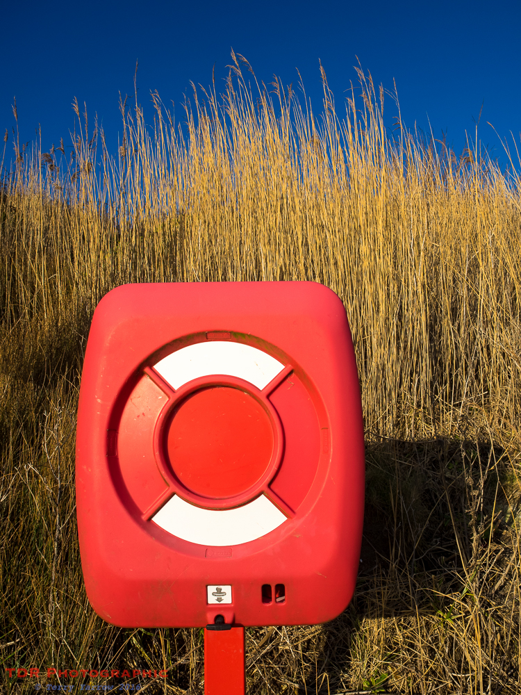
I was glad of my flask of hot drink as it soon became chilly sitting on a cold rock. To warm up, I wandered around with the camera looking for picture opportunities……like the one below 🙂 !
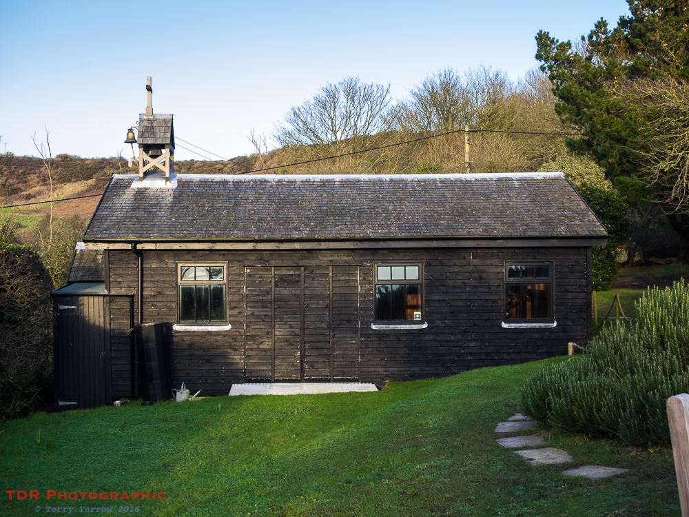
All too soon I had to move on, which meant some steep climbs! The first of these was up to the top of the White Nothe headland. Part way up I stopped to look at a quaint little wooden church at another small hamlet, Holworth. This wooden chapel still has regular services despite its remote location and in fact it has recently been extended. It stands right on the cliff edge with amazing views across the water.
My walks are often like pilgrimages as I pass many churches and I like to stop and pray in each one. On this occasion, however, with boots thickly coated with mud, I just sat on the bench outside. Well, with that view, who wouldn’t!
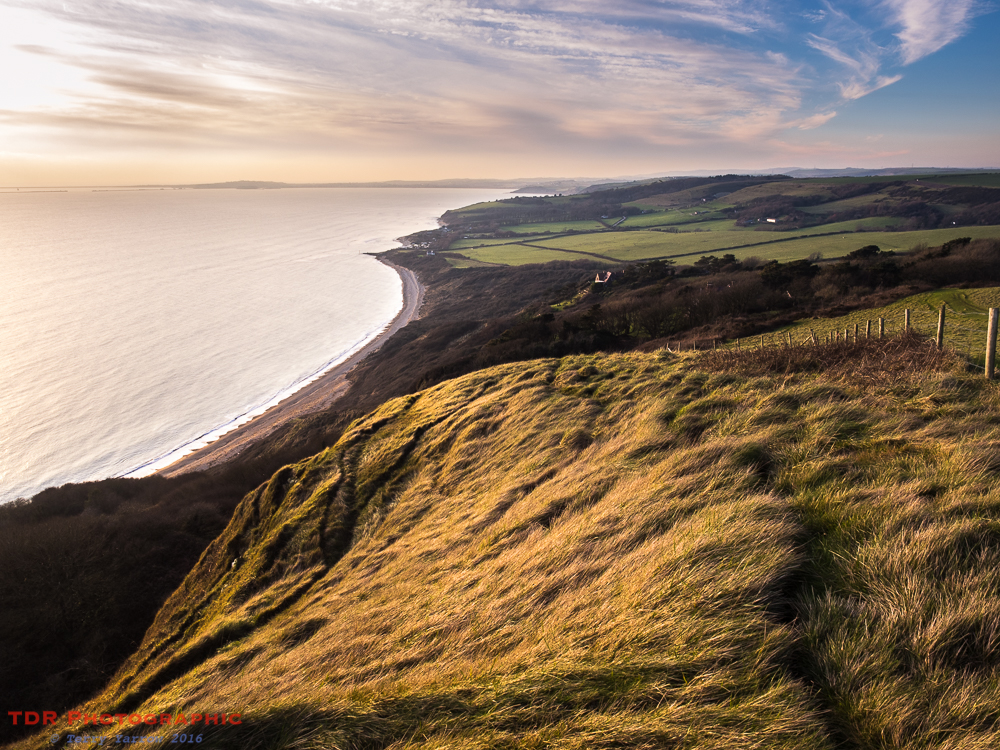
Onwards and upwards I went, eventually reaching the top of the headland, a beautifully rugged and wild wilderness of a place. I so enjoy exploring this remote headland. It has a real air of mystery and intrigue about it.

One of its features is its row of old coastguard cottages. Remote and unserved by any roads, these cottages have no mains services – the residents collect rainwater, heat by log burner, light by gas lamp or LPG generator, and drain into cess pits. These seven terraced cottages are not for the faint hearted but the largest changed hands recently for some £470,000! Recently the captain’s house has been brought more into the 21st century by installing solar panels on the roof. I have a feeling that the owners may have bought the house next door as well…….so maybe there are now only six?
They are quiet cottages now, mainly used as holiday or second homes, but at one time they were home to seven families with a total of 44 people living in them. The captain of course lived in the largest, three story house, and his 6 men and their families lived in the others. Together they tried to keep our coast safe as there was a thriving smuggling trade all along this part of the coast. And you can really picture in your mind the events that took place here with its remoteness and its secret paths.
When the coastguards vacated the cottages, they passed into private ownership and one of the early residents was the author Llewelyn Powis. A memorial stands nearby.

Despite their remoteness, in fact because of their remoteness, and their lack of modern ‘trappings’, this would be an amazing place to live. And who could possibly not delight in the view below back down to Ringstead Bay?
And of course that’s not to mention the view out to sea!

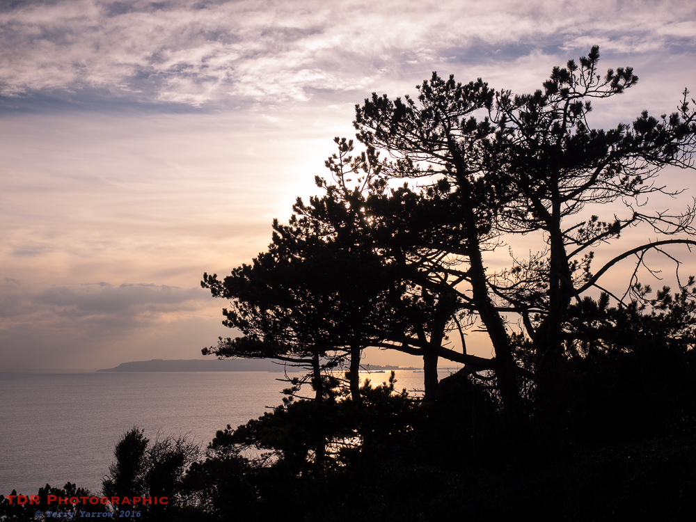
The sun was getting low in the sky by now and there was a definite chill in the air. Fingers were being numbed by the cold so it was time to move swiftly on. I left the White Nothe and continued on my way. Ahead of me I could see the switch back of headlands that were to be my route from here and I knew that I would once again, as I had done many times before, be walking in the dark before I reached my finishing point! But hey, that is often the best time of the day.

By the time I dropped down to Durdle Door, the sun had gone and the light had a definite blue tinge to it – this is the photogenic blue hour. I have a thousand pictures of the view below but you just cannot help but take more each time you pass this way. This really is a magnificent coastline, as good as you will see anywhere in the world!

When I reached the arch, projecting out of into the water like some huge and fearsome sea monster taking a drink, it was virtually dark. Everywhere was still and there was just a faint tinge of orange in the distant sky. The only sound was the washing of surf on shingle. The lights of Portland and Weymouth twinkled in the far away lands and had it been summer, I would have sat and drank in the awesome atmosphere. But tonight was now icy cold!

I left the coast and climbed up the last hill of the day and in complete darkness with just the stars and a faint moon for company, and the ever diminishing sound of the waves, lost in my own thoughts, I made my way home.
Thanks for stopping by.
Until next time,
Your friend The Dorset Rambler
I HAVE NOW SET UP A FACEBOOK PAGE FOR THE DORSET RAMBLER AND THERE IS A LINK ABOVE. THIS IS TO BRING TOGETHER MY THREE PASSIONS OF DORSET, WALKING/THE OUTDOORS, AND PHOTOGRAPHY. IF YOU ARE INTERESTED IN THESE OR YOU ENJOY MY BLOG, PLEASE DO ‘LIKE’ MY FACEBOOK PAGE.
If you would like to contact me, my details are on my website which is http://www.yarrowphotography.com – comments and feedback are welcomed.
All photographs, poems and words in this blog are the copyright of The Dorset Rambler and must not be reproduced without permission.

What is the purpose of red and white box in the photo entitled, “An Exercise in Colour – Ringstead Bay”?
Hi Victoria. The red and white box contains a life belt in case anyone gets in trouble in the water.
Good to know if I ever go swimming in Ringstead Bay.