
 with King Arthur on The Snowdon Horseshoe :)")
I have a number of ‘favourite’ walks (if that is not an oxymoron!) and one of these is the fabulous Snowdon Horseshoe which I had a chance to enjoy again on our recent holiday in North Wales. I say ‘walk’ although I’m not sure it can really be classed as that because much of it is a grade 1 scramble or perhaps even more severe depending on the route you take. I guess part of the reason I enjoy it is because it is in many ways in stark contrast to walking in Dorset which is much more about beautiful rolling countryside than the ruggedness which is everywhere in Snowdonia.
The route started at Pen Y Pass, the high point on the pass that cuts through the mountains at Llanberis and the first part followed the route of the Pyg Track, one of several paths to the Snowdon summit. It is a very craggy path and gets its name from the Pen Y Gwryd, a nearby hotel much used by the early climbers.
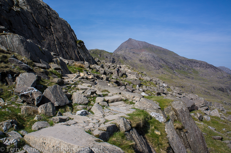
On the Pyg Track with Crib Goch in the distance
The Pyg Track is a relatively straight forward introduction to the main walk on the Horseshoe route but I followed it only as far as Bwlch Y Moch (pass of the pigs) where the main work began! From here, whilst the Pyg Track continued its way more directly onto Yr Wyddfa, the highest summit of Snowdon, my route left that track and headed directly up the very steep and craggy mountainside onto the top of Crib Goch.
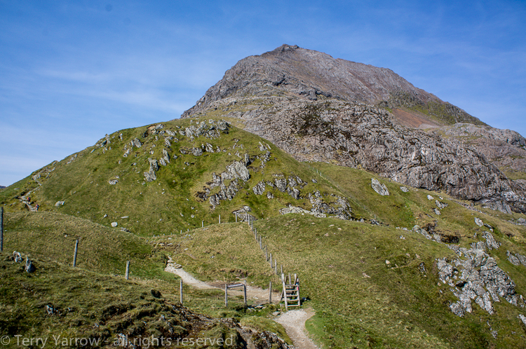
The Pyg Track winds its way on but my route was directly up the mountainside ahead
It may seem strange to take the most difficult route when there is a much easier way but I have to say that the rewards are great! Crib Goch is one of the best scrambles in Wales, it is both extremely challenging but also do-able and I do love a good scramble where you are required to use hands and feet to haul yourself to the top which in the case of Crib Goch is at 3,000 feet. And having overcome the challenges of the ascent, you are greeted by the sight below :)!
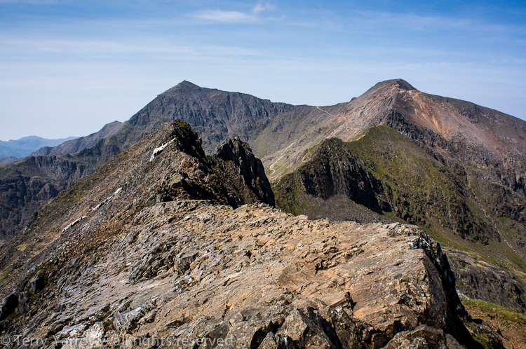
The arete of Crib Goch with the distant peaks of Garnedd Ugain (right) and Yr Wyddfa (left)
In the picture above, you can see the route from this point which follows the top of the ridge which zig zags its way eventually to the Snowdon summit and then continues down the ridge to the left to climb over several more peaks before dropping back down off the mountain. The whole ridge is extremely exposed and you feel quite vulnerable with the sheer drops down each side, particularly when the wind whips across the top. It is even more exposed when the weather is bad……..but I was blessed with good weather :)! In fact of course it is that very exposure that makes it such an awesome ‘walk’, as well as the fabulous views that are all around! The highest point along the Crib Goch Arete are the Pinnacles which you can see in the pictures below. It is possible to skirt round these but being a purist ridge walker, my route went over the top!


The Pinnacles
Having made my way across Crib Goch, the route eased off slightly for a short time at Bwlch Goch, a slightly lower pass on the ridge.

Looking back at Crib Goch from Bwlch Goch
But not for long! Looking ahead, the bulk of Crib Y Ddysgl (rake of the dish) loomed up – this is another scramble leading to the top of Garnedd Ugain. You can get something of the scale in the picture below because there is someone dressed in red just starting the climb.

Crib Y Ddysgl and Garnedd Ugain loom ahead
I said before that the views are amazing from all along this ridge. Far below is Glaslyn which literally means ‘blue lake’ – this sits below the Snowdon summit.

Glaslyn and Yr Wyddfa, the Snowdon summit
And looking back from Garnedd Ugain, you can see where the route has taken me so far.

Looking back at Crib Goch from Garnedd Ugain
Fron Garnedd Ugain, the walk was fairly straight forward for a time (and at this point it is a walk 🙂 ) across the col of Bwlch Glas and up the slope to the main Snowdon summit. The main difficulty here is simply the number of people on the top as there are ‘tourist’ routes and even a rack and pinion railway up to that point. And on top is the inevitable cafe!! When I walk, I prefer to be away from the crowds so I hurried straight through and onto the next part of my ‘walk’.

Looking west from Bwlch Glas across Glaslyn and Llyn Llydaw
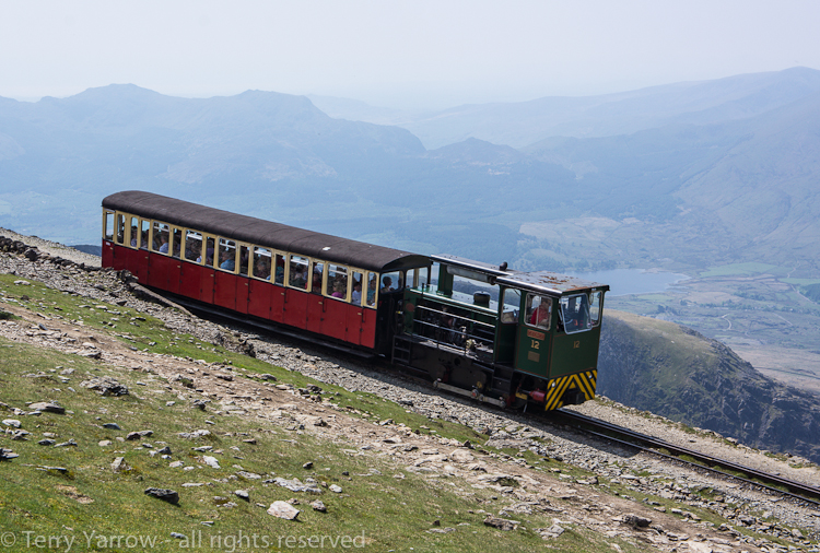
The Snowdon Mountain Railway
You might think that dropping down off the summit would be easier but actually it isn’t! For a lot of the time, the route drops down a scree slope with lots of loose rocks which can be lethal if you are not careful. If you are not reasonably sure footed, you could wind up on your backside numerous times, or worse, not to be recommended! Mind you, I felt a bit smug when I passed the people in the picture below as they still had a long way to go before reaching the top!

Dropping down the scree slope from the summit with Llyn Llidaw far below
Eventually, the path did level off onto a better surface at Bwlch Y Saetheau (pass of the arrows). This is said to be where King Arthur’s knights fought their last battle and tradition has it that they are still waiting for the battle trumpet to wake them up to rid Wales of the Saxon invaders! The better footpath did give a good opportunity to enjoy the views…..except that those views included the twin peaks of Y Lliwedd which of course I had to climb up and over!!

The view from Bwlch Y Saetheau with Y Lliwedd in the distance
And as I got nearer, the slope up to the peaks seemed even more steep!

Y Lliwedd – the only way is up!
Having moved on from the main summit, I left the crowds behind and apart from some other walkers in the distance, it was just me with seagulls for company! Where there is food, there are seagulls – at this point I had decided that an afternoon snack was called for!

Where there is food, there are seagulls!
From Y Lliwedd there are great views across Llyn Lliddaw which is a huge Snowdon reservoir nestling in the valley and surrounded by the Horseshoe – you can see Crib Goch across the lake in the picture below. According to some, Llyn Llydaw is the famous Arthurian lake from which Excaliber appeared and later returned. From this point, it really was all downhill to the shore of Llyn Llidaw, although again it was down rocky scree slopes and over rough ground so definitely a testing downhill section. In fact it is so hard on the feet and it was such a hot day that it was a relief to get back onto more level ground again and to sit on the edge of the lake and soak my feet for a while :)!

Llyn Llydaw, a Snowdon reservoir
The final stretch of the walk was along the very well surfaced (and level) Miners’ Track which was, as the name suggests, used by workers when Snowdon was being mined for copper. The mine itself is beside Glaslyn, immediately below the summit, but there are old mine buildings beside Llyn Teyrn, the lake in the picture below.
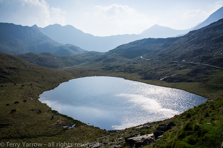
Llyn Teyrn with the Snowdon range in the distance
As I walked round Llyn Teyrn on the final stretch of a stretching walk, I turned and looked across the lake with its old mine buildings to the Snowdon range as the sun began to fade to blue and I was a deeply satisfied man :)! What a great day!
Thanks for stopping by and reading the ramblings of The Dorset Rambler!
Your friend
The Dorset Rambler
All images in this blog are the copyright of The Dorset Rambler and must not be used without permission.

You call it a walk or scramble. I call it “needing to soak my feet in that beautiful lake afterward.” 😉 But it all looks beautiful.
Thanks EEE. It was beautiful. There were a couple of people who swam in the lake but it was a very short one as the water was freezing! As it is a reservoir, I’m not sure you are allowed to swim anyway 🙂
wow! what a place!
Terry, what you do on these walks is amazing. And your enthusiasm is definitely catching. Thanks for continuing to share your experiencesa and your excellent photos.
Thanks Sandra 🙂 I just enjoy what I do really and I am blessed to have the good health that enables me to do it 🙂
I think – no, I KNOW – I would see those panoramic vistas and just cry. It has got to be so overwhelming to see such beauty. Thank you for sharing. Really, thank you.