

I thought that today I would put up another of those great ‘off the beaten track’ walks that I enjoy, a walk that skirts round part of the Poole Harbour shoreline.
It starts from the Sandbanks Ferry. This is the ferry that goes back and forth across the entrance to Poole Harbour – the landing point on the other side is the land that you can see in the distance on the left in the picture below. When the tide is running, there is a tremendous pull on the chains that hold the ferry and links have to be removed regularly to keep the chains to the right length – about 2 links have to be taken out every fortnight . The chains last around 15/18 months and then have to be replaced (at a cost of £24,000 in 2006) – interestingly, the old ones are sold off in sections mainly to local fishermen who use them as weights for boat moorings etc. Another interesting fact is that the chains wear more on the Sandbanks side (where the ferry is in the picture) than they do on the Shell Bay side! A ferry has been running across the harbour entrance since 1926 and the current one, known as Bramble Bush Bay, is the fourth one. It takes around 50 cars at a time and can be a real log-jam in the summer – but it does save a long drive around the harbour.
Just another interesting fact before we get walking – the original idea to get across the harbour entrance was to build a transporter bridge but since the cross channel ferry goes in and out of this entrance, that would have been somewhat inconvenient!

The Sandbanks Ferry
The first, somewhat unusual, thing you notice when you come off the ferry is the ‘famous’ Shell Bay telephone box which sits virtually on the beach with no houses to speak of anywhere near. It is probably the most photographed telephone box in the land ;)!

The most photographed telephone box in the land??
Having reached Shell Bay, most people head to the east side and walk along the beach as it is much easier, but our ‘alternative’ walk takes us to the west side of the peninsula, along the shores of Poole Harbour. This is not an easy walk especially if the tide is in but it is very rewarding!
After a short distance, you come across one of those quirky things of Dorset – Bramble Bush Bay (from which the ferry gets its name) with its somewhat strange houseboats! There are two ‘permanent’ houseboats here that have been embedded on concrete bases. Both of them lean crazily – you can see that the one in the picture below slopes at something like 20 degrees. You might assume that they are derelict but in fact they are both still occupied in the summer, and not only that but they are joined by another four or five more houseboats for the summer season. Having done some research into these boats (can they still be called that if embedded firmly in concrete?), I understand that they can remain there permanently but cannot actually be replaced (I assume they would be granted mooring rights only if replaced) so they are being held together by ‘sticking plaster and string’ to extend their lives as long as possible. In fact the decks inside have been levelled – I guess it could be quite difficult to sleep otherwise ;)!

Bramble Bush Bay
A little further along you pass a string of huge concrete blocks reaching out into the harbour. These are often referred to as Dragon’s Teeth, a war time anti tank defence but I have never actually been able to prove that that is what these are. What makes me doubtful is that they do not stretch inland which would seem a strange sort of defence. I wonder if they are in fact the remains of an old landing stage – there were several along this part of the harbour shore. I need to do more research. Either way, they make an interesting subject for photographs – and are useful for cormorants as well!

Dragon’s teeth?
Rounding the point, you come across Redhorn Quay which was once an important landing stage for boats sailing from the Studland area to Brownsea Island, mainly when it had its pottery industry, and other places. It has long since been abandoned and all that remains are the hulks of one or two boats rotting away. These days the quay sees only waders foraging for food and the occasional walker like me but it is a lovely wild place. The wreck at Redhorn is not technically a wreck, it is just an old metal hulled barge that was left there and has rotted away over the years. There are a few ‘wrecks’ like this one in the harbour, as well as some real wrecks on the sea bed. These have to be regularly surveyed to make sure they have not moved as they could constitute a danger to the ships and boats that use the harbour. I got chatting to the man whose job it is to dive to these wrecks and cary out the survey – well it beats a desk job doesn’t it!
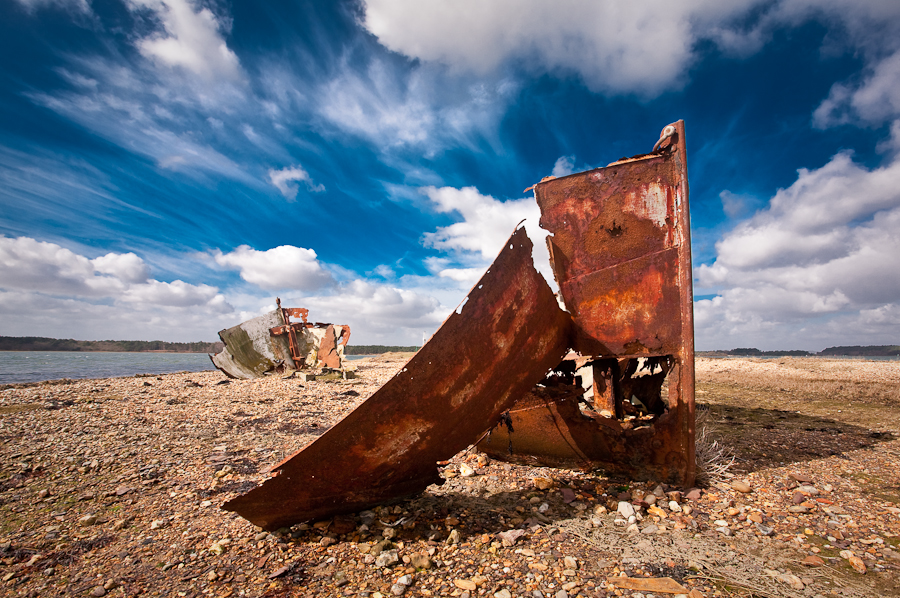
Redhorn Quay
This part of the harbour shoreline abuts Studland Heath Nature Reserve so there is much wild life to see, including many deer and waders. There is a hide facing onto the harbour shore. This is a part of Poole Harbour that I love – left to nature, it is a complete contrast to the north harbour shore which is heavily populated.

One of the harbour inlets – part of the harbour left to nature
To continue to walk round the harbour shore is difficult. In the picture above, our walk has taken us along the right shoreline but the left shoreline leads back out to the Goathorn Peninsula which is private. Further along, the only points where there is public access to the harbour shore are at Ower and the RSPB run bird reserve at Shipstal Point. I personally think this lack of access is a crime! I believe that there should be public access to all water fronts, whether it be sea, harbour or river and I think the Right to Roam should extend to this! I know that apart from public footpaths, some land has been designated Access Land, but in my opinion it is far too little! Poole Harbour has 100 miles of coastline but too much of it cannot be accessed!
I find it quite bizarre that it has recently been announced by the government that ‘The Dorset Coast Path has been opened’ – the link is below. I’ve lived all my life in Dorset and much of that has been spent walking the coast and for as far back as I can remember, there has been a path. So how come the big announcement? How about creating a path and granting access where there currently is none, rather than scoring cheap brownie points by ‘opening’ up paths that for the most part have existed for years!!! Just imagine if there was a new long distance footpath all around Poole Harbour! Maybe if the Olympic sailing events had been held at Poole we might have got that – but I doubt it!!
http://www.bbc.co.uk/news/uk-england-dorset-16751214
Poole Harbour is often quoted as the second largest natural harbour in the world and as mentioned, it has over 100 miles of coastline. It has five main islands but probably more than double that at low tide. It is also a very shallow harbour with an average depth of just 48cm, although channels have been dredged to allow large boats to navigate to Poole Quay, including cross channel ferries. Parts of it are wonderfully wild and make fabulous areas to walk or watch wildlife, two of the things I love to do! This walk is not easy and can be boggy underfoot but it is a walk I always enjoy!
Thanks for stopping by and for reading the ramblings of The Dorset Rambler!
A very happy Easter to you all!
The Dorset Rambler

I never knew the chains wore down more on the sandbanks side!! Why is that?
I think it is just the strength of the tide – I’m guessing that the tide running out of the harbour is stronger than the tide running in, because it has nowhere else to go but out through the entrance 🙂
Humm that’s really interesting!!
Apparently its not only that – the water is deeper on the Sandbanks side as well and that causes more abrasion on the links 🙂
Great photos of places I know well
I missed this one too. The inlet harbor is so beautiful!
Thanks Sandra 🙂
What a wonderful article and photos, I enjoyed it very much. By the way, I have lived in Poole all my life and absolutely love Poole Harbour. 🙂
Thanks Sarah 🙂
In my teens my Parents used to hire one of these houseboats for two weeks or more and we used to spend our Summer Holidays. We mostly stayed on I thinki it was called “White Wing” and it was the very end one furthest away from the Ferry. We used to walk to Lovels Cafe by the Ferry every day for Milk etc., My Grandfather was either at school with old Mr. Lovel who had a wooden leg or he taught him. For a swim we would put on our bathing costumes and run barefoot across the headland to the Studland Bay side go for a swim and run all the way back. Looking back it was idyllic but I didnt appreciate it at the time. Ann
Hi Ann. Thanks for your very interesting comments. The boat you stayed in would have been one of the moveable ones rather than the fixed ones which are now on concrete bases. The cafe has changed considerably since those days of course. The beaches, in fact the whole area certainly idyllic 🙂
Thanks for writing this brilliant article. I have come across it while looking for alternative access to the southern shores of the harbor. Like yourself, I too think it an injustice that there is not more public access to what is some of the most beautiful areas in Dorset. The only reason people don’t complain I believe, is because they don’t realise what they are missing!
Thanks for your kind comment Dean. Yes, I agree, people don’t know what they are missing. I had hoped that ‘right to roam’ might have a greater impact!
I came across the converted house boats at bramble bay today and spoke to one of the owners who had just come ashore in long waders. He told me that his and most of the others there had been constructed from WW2 tank barges. His was a recoverd sunken tank barges and had been built of steel and mahogany. He said that they had been allowed to originally moor them there by the Lady who had owned Brownsea Island up until the 1960s. When the National Trust took over they wanted to evict them and destroy the boats but they managed to stop this only by taking the Trust to Court. They are now allowed to keep them there but they can’t replace them, only maintain them. Barry Harmsworth
Hi Barry. So sorry, I have only just picked this up. Thanks for your comment, it is most interesting. I hadn’t realised that the NT had tried to have the boats removed and I’m glad they failed because I think the boats are a lovely, quirky part of Poole Harbour 🙂